Farmhouse for sale in Aveton Gifford, Kingsbridge TQ7


* Calls to this number will be recorded for quality, compliance and training purposes.
Property features
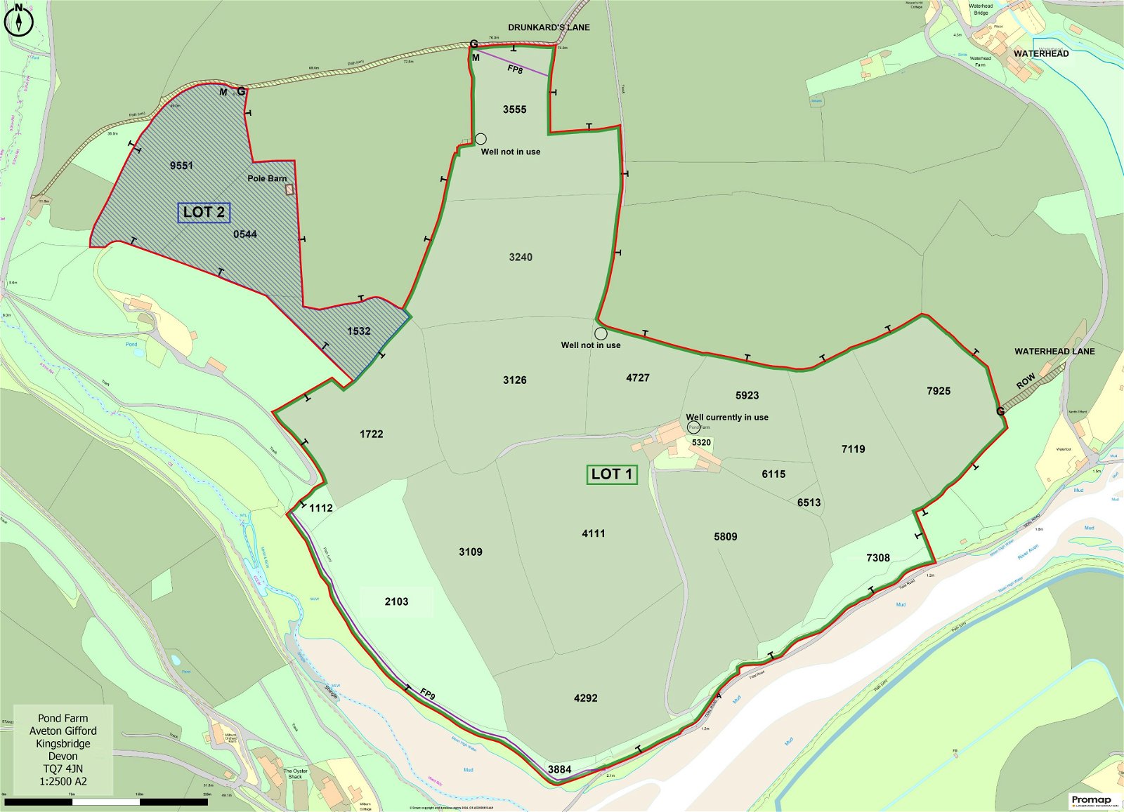
- Approximately 90.07 acres in all
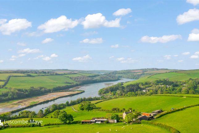
- Breathtaking views across the River Avon and the tidal estuary
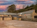
- Range of Stone Barns and Modern Farm Buildings
- Offered for sale as a whole or in up to 2 lots to suit purchasers requirements
- Lot 1 – 79.92 acres (32.32 hectares)
- Lot 2 – 10.15 acres (4.10 hectares)
- Offering the potential to create an iconic property in an unrivalled location
Property description
Directions
From Aveton Gifford, proceed along the tidal road towards Bigbury. Approximately half a mile along this road turn off to the right which will lead into the driveway leading up to Pond Farm.
What3Words Location: Picked.operating.trip
situation
Pond Farm is situated near the village of Aveton Gifford, between the villages of Aveton Gifford and Bigbury, in the South Hams area of South Devon and within an area designated as a National Landscape (formerly known as Area of Outstanding Natural Beauty).
The nearest town of Kingsbridge is about 4 miles away, the city of Plymouth some 15 miles to the west and the A38 dual carriageway expressway, connecting to the M5 motorway and national road network, being about 10 miles to the north.
Description
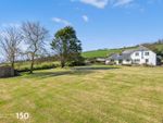
Pond Farm comprises a residential and livestock farm, to include a farmhouse, detached bungalow, range of traditional and modern farm buildings and some 90.07 acres of agricultural land, the full extent of which is as approximately outlined in red on the site plan.
The farm has been divided into two lots (as can be seen from the site plan) and buyers are invited to submit offers on one or both lots as may suit their requirements.
The principal access to the farm is gained off the council maintained tidal road, between the villages of Aveton Gifford and Bigbury. Access is restricted to particular hours of the day based on tidal movement.
There are two alternative accesses to Pond Farm. Firstly, an alternative access may be gained over the public byway Drunkards Lane into field parcel 3555. The second alternative access to the farm may be gained via a Right of Way over Waterhead Lane to a gateway on the eastern boundary of field number 7925 however this is not currently in use. Both alternative access points are labelled and approximately shown by a brown hatched line on the site plan.
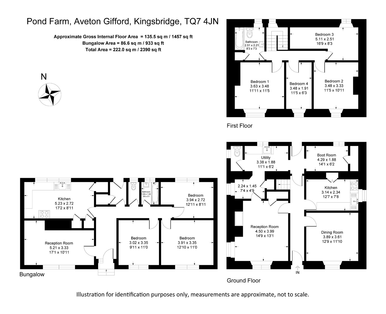
Lot 1 - Farmhouse, bungalow, stone and modern farm buildings and agricultural land, extending to 79.92 acres in all (outlined in green on the site plan)
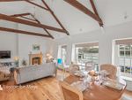
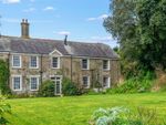
Farmhouse
Not of listed status, the farmhouse is believed to have been constructed in 1830, built mainly of rendered solid stone walls with parts being slate hung and under a slate roof. The property comprises the following accommodation:-
Ground Floor
Entrance Hall, Sitting Room, Dining Room, Kitchen, Rear Entrance Porch, Boot Room/Store, Utility Room, Separate WC
First Floor
Landing, Family Bathroom, 4 Bedrooms
Services
Mains water, electric and private septic tank drainage. Solar panel on roof heats water for bathroom and utility room. Meters for the water supply can be identified on site plan by the letter M.
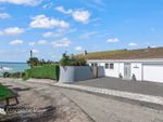
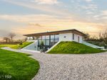
Pond Cottage (Bungalow)
A detached bungalow of Woolaway construction, built in approximately 1965/66 with an interlocking concrete tile roof. This property is subject to an Agricultural Tie whereby only those persons previously or currently working full time in agriculture or forestry are permitted to reside in the dwelling.
The property comprises the following accommodation:-
Entrance Hall, Sitting Room, Kitchen/ Dining Room, Separate WC, Bathroom, 3 Bedrooms, Rear Entrance Porch
Services
Mains water (on the same meter as the farmhouse), electric and private septic tank drainage (both separate from the farmhouse). Economy 7 electric tariff by night for the water heater and night storage heaters.
Stone Barns
Extending to a total area of some 296 square metres (3,186 square feet) over two floors, the stone barns do not have planning consent for change of use to residential but offer the potential for such change of use either as full residential units or as holiday ancillary use. These may be summarised as follows:-
Modern Farm Buildings
Within close proximity of the farmhouse (and partly amongst and linked to the stone barns) is a range of modern farm buildings, extending to a total area of some 614 square metres (6609 square feet). Brief details of which are as follows:-
The Lands
The full extent of the land for this lot amounts to some 79.92 acres (32.32 hectares).
The land wraps around the farmhouse and buildings providing a significant amount of protection from other properties.
The land in the past has been used for livestock grazing and grass conservation purposes but offers the potential for other uses subject to obtaining the necessary consents.
The land to the east and south side is served by a well water supply. There are three wells located on the land, of which one is currently in use. The approximate locations are marked on the site plan. The remaining water troughs within close proximity to the house & buildings are fed by the mains supply that also serves the farmhouse.
A schedule of Lot 1 is set out below :-
Field Number Acres Hectares Description
sx .20 0.89 Woodland
sx .35 0.14 Woodland
sx .13 0.86 Woodland
sx .50 2.22 Permanent Pasture
sx .09 2.06 Permanent Pasture
sx .40 2.59 Rough Grassland/scrub
sx .40 2.18 Permanent Pasture
sx .28 2.54 Permanent Pasture
sx .02 2.84 Permanent Pasture
sx .62 3.49 Permanent Pasture
sx .87 1.16 Permanent Pasture
sx .76 3.14 Permanent Pasture
sx .77 1.93 Permanent Pasture
sx .16 1.28 Permanent Pasture
sx .10 0.04 Permanent Pasture
sx .74 0.30 Permanent Pasture
sx .21 0.08 Fruit trees/ garden
sx .74 1.92 Permanent Pasture
sx .41 2.19 Permanent Pasture
- 1.17 0.47 House, Curtilage, Buildings, Driveway
Total 79.92 32.32
lot 2 – Land Part Pond Farm (10.15 acres) (hatched in blue on the site plan)
This lot comprises 10.15 acres (4.10 hectares) of land located on the west side of the farm.
Access to the land may be gained off Drunkards Hill public byway which runs along the north boundary and is highlighted by the brown hatched line on the site plan. This access would be suitable for 4x4 vehicles.
This lot includes a pole barn which measures approximately 12.80m x 4.90m (62.72 square metres), this having been used in the past for storage of fodder and/or farm machinery.
There is a separate metered water supply that serves this lot, and the approximate location of the meter is marked on the plan by the letter M. A schedule of Lot 2 is set out below:-
Field Number Acres Hectares Description
sx .83 1.95 Permanent Pasture
sx .61 1.46 Permanent Pasture
sx .71 0.69 Permanent Pasture
Total 10.15 4.10
public footpaths
Public footpaths proceed through part of the farm along the south-west boundary and along the northern end of field parcel 3555. The routes of the footpaths are labelled and approximately shown on the site plan by means of a purple line.
Boundary ownership
Boundary ownership, as far as are known are shown by the ‘T’ markings on the site plan.
Tenure
The property is held on a freehold basis with vacant possession being available on legal completion.
Sporting and mineral rights
All sporting and mineral rights are included in the sale, as far as are known.
Environmental stewardship scheme agreements
Pond farm is not subject to any Environmental Stewardship Scheme agreements.
Local authority & council tax
South Hams District Council, Follaton House, Plymouth Road, Totnes, Devon TQ9 5NE.
Pond Farm falls within Council Tax Band C and the amount payable for 2023/24 is £2,106.40.
Pond Cottage falls within Council Tax Band A and the amount payable for 2023/24 is £1,579.81.
EPC
Pond Farmhouse has an EPC rating F with potential for C.
Pond Cottage (Bungalow) has an EPC rating of F also with potential for C.
The full EPC ratings are available on the listing.
Guide prices
Lot 1 £1,250,000
Lot 2 £100,000
Whole £1,350,000
method of sale
The property is being offered for sale by Informal Tender (unless sold prior), such that buyers are invited to submit their highest and final offers in a sealed envelope by Thursday 4th July 2024 at 12 noon Tender forms are available on request from the Sole Selling Agent.
All tenders must be submitted to 62 Fore Street, Kingsbridge, TQ7 1PP in an envelope clearly marked ‘Pond Farm, Aveton Gifford’.
The seller does not undertake to accept the highest or any of the offers and the seller reserves the right to withdraw, alter or amend the way in which the land is offered for sale.
Buyer(s) will be required to exchange contracts within four weeks of their solicitor receiving a draft contract.
Viewings
Strictly by appointment with the Sole Selling Agents, Luscombe Maye of 62 Fore Street, Kingsbridge, TQ7 1PP. Telephone for details.
Health & safety
Any prospective purchasers of whom would like to view the land do so at their own risk. The vendors nor their selling agent accept any responsibility in any incident or accident that may happen.
Property info
For more information about this property, please contact
Luscombe Maye - Land & Farms, TQ7 on * (local rate)
Disclaimer
Property descriptions and related information displayed on this page, with the exclusion of Running Costs data, are marketing materials provided by Luscombe Maye - Land & Farms, and do not constitute property particulars. Please contact Luscombe Maye - Land & Farms for full details and further information. The Running Costs data displayed on this page are provided by PrimeLocation to give an indication of potential running costs based on various data sources. PrimeLocation does not warrant or accept any responsibility for the accuracy or completeness of the property descriptions, related information or Running Costs data provided here.
Properties on the market nearby


Marketed by
Luscombe Maye - Land & Farms
(view all properties)
62 Fore Street, Kingsbridge, TQ7 7PP
- Member of:
-

-

-

- Monday: 09:00 - 17:30
- Tuesday: 09:00 - 17:30
- Wednesday: 09:00 - 17:30
- Thursday: 09:00 - 17:30
- Friday: 09:00 - 17:30
- Saturday: 09:00 - 13:00
- Sunday: Closed